 |
 |
 |
 |
| "Mountain Meadows Inn" in the mountains near Asheville NC bbcxf001a01-09 |
Southern Railway Station, Asheville NC bbcxf001a01-10 |
South Side Pack Square, Asheville NC bbcxf001a01-11 |
Biltmore Church, Biltmore NC bbcxf001a01-12 |
 |
 |
 |
 |
| Pack Square, looking East, Asheville NC bbcxf001a01-13 |
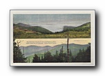
A Mountain Stream "In the Land of the Sky" North Carolina bbcxf001a01-14 |
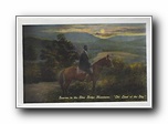
Sunrise in the Blue Ridge Mountains "The Land of the Sky" (horseback) bbcxf001a01-15 |
Southern Railway Company's Train No. 11, Crossing the Blue Ridge Mountains, "In the Land of the Sky" bbcxf001a01-16 |
 |
 |
 |
 |
| Southern Railway Company's Train No. 11, Along the French Broad bbcxf001a01-17 |
The Poetic Swannanoa "In the Land of the Sky" bbcxf001a01-18 |
Mount Pisgah and the Rat, North Carolina "In the Land of the Sky" bbcxf001a01-19 |
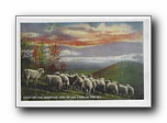
Sheep on the Mountain Side, In the Land of the Sky bbcxf001a01-20 |
 |
 |
 |
 |
| Fountain at Round Knob NC, "On the Line of the Southern Railroad" bbcxf001a01-21 |
On the Top of Craggy Mountains near Asheville NC (horseback) bbcxf001a01-22 |
Mount Mitchell, "In the Land of the Sky" bbcxf001a01-23 |
Railroad at 17 Points "In the Land of the Sky" bbcxf001a01-24 |
 |
 |
 |
 |
| (folder) Souvenir "Land of the Sky" Western North Carolina (22 cards / 0 BR) bbcxf002a01-01 |
(back of folder) (unmarked) double tunnel bbcxf002a01-02 |
Bird's Eye view of Hendersonville NC / Lake Kanuga, near Hendersonville NC bbcxf002a01-03 |
Bird's Eye view of Waynesville NC / View of Plott's Balsam from Waynesville NC bbcxf002a01-04 |
 |
 |
 |
 |
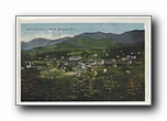
| Bird's Eye view of Black Mountain NC bbcxf002a01-05 |
Railroad at Seventeen Points bbcxf002a01-06 |
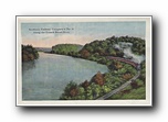
Southern Railway Company's No. 11, Along the French Broad River bbcxf002a01-07 |
Above the Clouds on Craggy Mountain (Altitude 5494 feet) In the Land of the Sky / Mount Mitchell (Altitude 6711 feet) and Clingman's Dome, highest Peaks East of the Rockies In the Land of the Sky bbcxf002a01-08 |