 |
 |
 |
 |
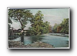
| The Lovely Swannanoa In the Land of the Sky (Lover's Bridge ?) x19-hmc25968a01-f |
x19-hmc25968a01-r x19-hmc25968a01-r |
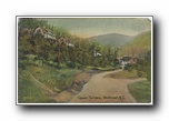
Upper Terrace, Montreat NC x19-hmcvhs285a01-f |
x19-hmcvhs285a01-r x19-hmcvhs285a01-r |
 |
 |
 |
 |
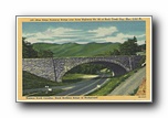
| Blue Ridge Parkway Bridge over State Highway No. 80 at Buck Creek Gap, Elev. 3,355 ft. / Western North Carolina, Black Brothers Rane in Background x19-hnm103a01-f |
x19-hnm103a01-r x19-hnm103a01-r |
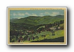
Mt. Pisgah, and the Rat, Alt 5749 ft, "In the Land of the Sky" Western North Carolina x19-hnm104a01-f |
x19-hnm104a01-r x19-hnm104a01-r |
 |
 |
 |
 |
| Mt. Mitchell, Alt 6684 ft, Highest Peak east of the Rockies, Western North Carolina x19-hnm108a01-f |
x19-hnm108a01-r x19-hnm108a01-r |
Winding Highway Cut thru Solid Rock, In The Heart of the Montains x19-hnm118a01-f |
x19-hnm118a01-r x19-hnm118a01-r |
 |
 |
 |
 |
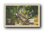
| A Typical Moonshine Still in the Heart of the Mountains x19-hnm129a01-f |
x19-hnm129a01-r x19-hnm129a01-r |
Appalachian Scenic Highway, Crossing the Blue Ridge Mountains x19-hnm130a01-f |
x19-hnm130a01-r x19-hnm130a01-r |
 |
 |
 |
 |
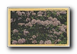
| Mountain Rhododendron in Bloom x19-hnm136a01-f |
x19-hnm136a01-r x19-hnm136a01-r |
Western North Carolina Sanatorium, near Black Mountain NC / c Curt Tech & Co, Inc. x19-hnm137a01-f |
x19-hnm137a01-r x19-hnm137a01-r |
 |
 |
 |
 |
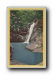
| Mitchell Falls, on the side of Mt Mitchell, Western North Carolina x19-hnm140-2ch1393-a01-f |
x19-hnm140-2ch1393-a01-r x19-hnm140-2ch1393-a01-r |
US Highway No. 70 crossing the Blue Ridge Mountains near Point Lookout NC (horizontal, no cars) x19-hnm140-5ah475-a01-f |
x19-hnm140-5ah475-a01-r x19-hnm140-5ah475-a01-r |